Menu
Life in GIS
Search

Life in GISLife in GIS

Menu
  • About
  • GIS
  • Remote Sensing
  • Geo-Stories
  • Downloads
  • GIS Terms & Definitions
  • QGIS Course
Search
close
Life in GISLife in GIS
close
  • About
  • GIS
  • Remote Sensing
  • Geo-Stories
  • Downloads
  • GIS Terms & Definitions
  • QGIS Course
Create a web map

Life in GIS is your go-to-site on GIS tutorials, Web-GIS Development, GIS Articles, Geo-Stories, Remote Sensing, UAVs, GIS Data, GIS Tutorials.The platform was established as an initiative to share knowledge within the GI sector in which tutorials, both text, and video, have been used for this purpose

Stay in the loop

GIS Applications
Categories
  • Posted inin GIS

10 GIS Applications You Probably Didn’t Know

  • Posted byby Christian Lance
  • 2 Comments
  • 4 min
  • 4 min
    • Share
Geographic Information Systems (GIS) has many applications and benefits, but perhaps the most overlooked application among many GIS...
  • Continue Reading
  • 4 min
Categories
  • Posted inin GIS

Climate change and GIS

  • Posted byby Risper Mutinda
  • 2 Comments
  • 4 min
  • 4 min
    • Share
What is climate change? According to the Intergovernmental Panel on Climate Change (IPCC), Climate Change refers to any...
  • Continue Reading
  • 4 min
Who is a GIS Specialist
Categories
  • Posted inin GIS

Who is a GIS Specialist?

  • Posted byby Wanjohi Kibui
  • 1 Comment
  • 3 min
  • 3 min
    • Share
A Geographic Information Systems (GIS) Specialist is responsible for managing and analyzing spatial data and systems. They utilize...
  • Continue Reading
  • 3 min
Geospatial technologies
Categories
  • Posted inin GeoStories
  • GIS

Geospatial Technologies: One-On-One with Stephen Mwai

  • Posted byby Risper Mutinda
  • 0 Comments
  • 6 min
  • 6 min
    • Share
The County Spatial Plan is a ten-year GIS-based depiction of a county’s socio-economic development vision and program, including the distribution of people and activities, within the context of efficient, productive and sustainable use of land and other county spaces
  • Continue Reading
  • 6 min
Categories
  • Posted inin GIS

GIS Week – Geospatial Awareness

  • Posted byby Risper Mutinda
  • 0 Comments
  • 2 min
  • 2 min
    • Share
As GIS enthusiasts, we all know that it’s one of the most exciting times of the year, the...
  • Continue Reading
  • 2 min
Remote Sensing Technology
Categories
  • Posted inin GIS
  • Remote Sensing

Remote Sensing Technology: Monitoring water hyacinth

  • Posted byby Risper Mutinda
  • 0 Comments
  • 3 min
  • 3 min
    • Share
Satellite imagery offers low-cost and effective monitoring of the temporal and spatial distribution of water hyacinth infestation at a large scale
  • Continue Reading
  • 3 min
Categories
  • Posted inin GIS

GIS Technology in the Health Sector

  • Posted byby Risper Mutinda
  • 0 Comments
  • 3 min
  • 3 min
    • Share
Introduction The astounding capability of GIS technology to enhance the healthcare industry has been realized over the past...
  • Continue Reading
  • 3 min
tensorflow and keras colab notebook
Categories
  • Posted inin GeoInformation
  • GIS

An Introduction to TensorFlow and Keras

  • Posted byby
  • 0 Comments
  • 2 min
  • 2 min
    • Share
Keras is a deep learning library that can run on TensorFlow among other platforms. TensorFlow is an end-to-end...
  • Continue Reading
  • 2 min
visualize changes over time
Categories
  • Posted inin GIS

Visualize changes over time in Google Earth Engine

  • Posted byby
  • 0 Comments
  • 1 min
  • 1 min
    • Share
Google Earth Engine is a powerful tool in many aspects. We can, for example, look at the visualization...
  • Continue Reading
  • 1 min
Visualization Parameters in Google Earth Engine Explorer
Categories
  • Posted inin GIS
  • Tutorials

Visualization Parameters in GEE Explorer

  • Posted byby
  • 0 Comments
  • 1 min
  • 1 min
    • Share
Visualization parameters enable a user to have a better view of the dataset. On the layers panel of the...
  • Continue Reading
  • 1 min
Layer Visibility in Google Earth Engine
Categories
  • Posted inin GeoInformation

Layer Visibility in the Google Earth Engine

  • Posted byby
  • 0 Comments
  • 1 min
  • 1 min
    • Share
This blog is a continuation of the Google Earth Engine Explorer Series, and we focus on the added...
  • Continue Reading
  • 1 min
Categories
  • Posted inin Tutorials

NDVI Time series in Google Earth Engine

  • Posted byby
  • 1 Comment
  • 1 min
  • 1 min
    • Share
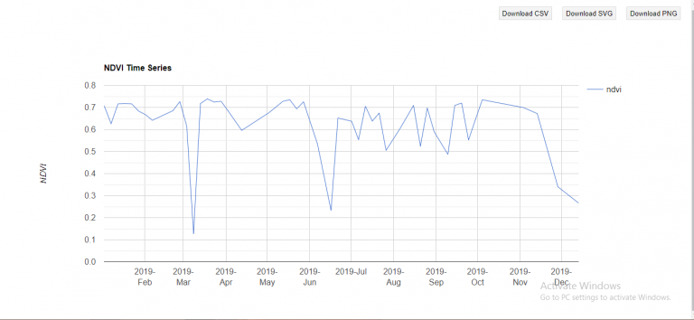
The Normalized Difference Vegetation Index (NDVI) is a spectral index used to quantify the greenness of vegetation. Earlier...
  • Continue Reading
  • 1 min

Posts pagination

  • Newer Posts
  • 1
  • …
  • 5
  • 6
  • 7
  • 8
  • 9
  • …
  • 13
  • Older Posts

New QGIS Course

Editors Picks

Chosen by the editor

    • GIS
    Things to Learn Before Others in GIS (and Why they Matter)
    • Posted Wanjohi Kibui
    • August 29, 2025
    • GeoStories
    GIS Is Disappearing and Nobody’s Talking About It
    • Posted Wanjohi Kibui
    • July 8, 2025
    • GIS
    Why Building Geospatial Web Apps is a Game of Trade-offs
    • Posted Wanjohi Kibui
    • May 1, 2025
  1. Web GIS development
    • Geodatabase
    Ultimate Web GIS Development Roadmap
    • Posted Wanjohi Kibui
    • November 12, 2024

Follow Us

Join us

  • twitter
  • facebook
  • youtube

Trending

Popular Posts

    • Web GIS
    Best Mapping Library: Perfect Tool for Geospatial Success
    • Posted Wanjohi Kibui
    • August 8, 2024
  • geospatial software development analysis
    • GIS
    Geospatial Software Development Cheatsheet
    • Posted Wanjohi Kibui
    • June 11, 2024
  • geospatial company
    • GIS
    Why Geospatial Companies are Key to the Future of Data Strategies
    • Posted Wanjohi Kibui
    • May 29, 2024

Editors Choice

Top Picks

    • GIS
    Things to Learn Before Others in GIS (and Why they Matter)
    • Posted Wanjohi Kibui
    • August 29, 2025
    • GeoStories
    GIS Is Disappearing and Nobody’s Talking About It
    • Posted Wanjohi Kibui
    • July 8, 2025
    • GIS
    Why Building Geospatial Web Apps is a Game of Trade-offs
    • Posted Wanjohi Kibui
    • May 1, 2025

Popular

Popular Posts

  • Open-Source Web Maps
    • Postedby Wanjohi Kibui
    • 1 min
  • Geodjango Tutorials
    Adding data to ExtJS grid from PostgreSQL
    • Postedby Wanjohi Kibui
    • 2 min
  • Publishing maps using QGIS Cloud
    • Postedby Wanjohi Kibui
    • 2 min
2025 © Life in GIS