GIS can be applied to solve diverse problems and aids in decision-making. Water hyacinth is one of the problems we have in our water bodies. Water hyacinth is one of the most presumptuous weed species in the world. It has led to serious adverse economic and ecological effects, especially in tropical and subtropical regions. It is critical to monitor areas with chronic hyacinth infestation so as to come up with efficient and effective strategies for controlling its spread. GIS and Remote Sensing can be used to control the spread of this weed species. Modern remote sensing technologies can be used to understand, monitor and estimate the infestation of water hyacinth within inland and coastal freshwater bodies.
Readily available satellite imagery with high spatial, spectral and temporal resolution, along with conventional and state-of-the-art machine learning technologies for automated image analysis, can enable the detection and discrimination of water hyacinth infestation from other floating or submerged vegetation. Remote sensing can potentially be integrated with a variety of other technology-based methods, including aerial surveys and ground-level sensors to provide timely, accurate and comprehensive water quality monitoring.
Remote Sensing Technologies for Monitoring Water Hyacinth
Satellite imagery offers low-cost and effective monitoring of the temporal and spatial distribution of water hyacinth infestation at a large scale. Over the last few years, the availability, frequency and coverage of satellite data has immensely increased, having several satellites, United States Geological Survey(USGS) Landsat missions with the most recent mission being Landsat 9 was launched on the 27th of September 2021 and European Space Agency (ESA) Sentinel 1 Sentinel 2. Some of the open-source satellite data, both optical and radar that can be used to monitor water hyacinth are Sentinel 1, Sentinel 2, Landsat 1 through Landsat 8, ASTER and NISAR.
Optical satellite imagery is more suitable for monitoring water hyacinth due to wide spatial coverage, high spatiotemporal resolution and a broad spectrum. Nonetheless, meteorological conditions and cloud cover adversely affect optical images since they are dependent on solar illumination. Radar images have an upper hand over optical images since they are not affected by day-night, clouds and weather conditions and can be integrated with optical images in operation systems.
The major focus of efforts using optical datasets has been to distinguish between hyacinth mats and algal blooms or other aquatic macrophytes. Due to enhanced spatial and spectral resolution sensors, the 10 m/pixel spatial resolution of Sentinel-2 Multispectral Instrument (MSI) has immensely enhanced research capability to detect and estimate water hyacinth infestation and coverage. Submerged macrophytes are clearly distinguished by their lower absolute reflectance in the near-infrared (NIR), while other narrow hyperspectral channels are used to discriminate species on the basis of leaf optical properties and other biophysical or biochemical properties.
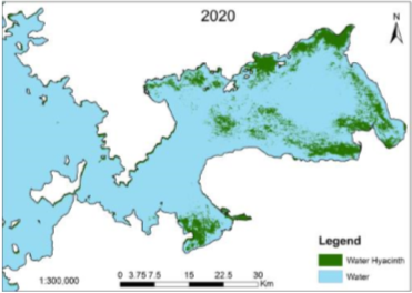
Water Hyacinth Extent in Lake Victoria in 2020

Additionally, critical water quality parameters such as Normalized Difference Vegetation Index (NDVI) and turbidity can be estimated with high levels of accuracy using remote sensing. NDVI is an index used to detect vegetation cover with values ranging from -1 to 1. Areas with high values of NDVI say from 0.8 to 1 signify the presence of healthy vegetation with low values indicating bare soil, water or snow.
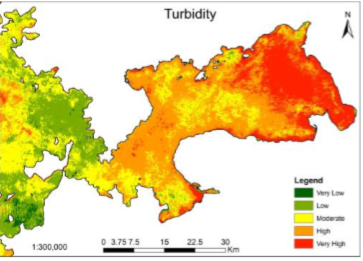
Turbidity Levels in Lake Victoria in 2020

The year 2020 turbidity levels are high around the coastal areas of Winum Gulf. This is caused by a high concentration of total suspended solids in the lake’s water, depicting a high level of both eutrophication and siltation in the shallow ends of the Winum Gulf.
Conclusion
Water hyacinth is one of the most presumptuous weed species in the world. It has led to adverse economic and ecological effects, especially in tropical and subtropical regions. Modern remote sensing technologies are used to understand, monitor and estimate the infestation of water hyacinth. The infestation occurs within inland and coastal freshwater bodies with the use of high spatial, spectral and temporal resolution satellite images and parameters such as NDVI and turbidity.


Remote Sensing Technology: Monitoring water hyacinth