Over the years, my journey in the geospatial industry has been nothing short of transformative. I’ve witnessed firsthand how mapping technologies have evolved, bringing us from static maps to dynamic, interactive digital maps that we use daily. As someone deeply immersed in this field, I’ve seen how the right GIS tools can make all the difference in a project’s success. One such tool is choosing the right mapping library.
When I started, the options for web-based mapping were limited and often cumbersome to implement. But today, we have a lot of powerful libraries at our disposal, each with its own strengths and ideal use cases. Whether you’re developing a simple interactive map or a complex geospatial application, choosing the right mapping library is crucial.
In this guide, I’ll share insights on when to use some of the top map libraries available: Leaflet, Mapbox GL JS, MapLibre GL JS, OpenLayers, and React-Map-GL. Drawing from my extensive experience, I’ll highlight the scenarios where each library excels, helping you make informed decisions for your geospatial projects.
Why Choosing the Right Mapping Library Matters
Selecting the appropriate mapping library is crucial for several reasons:
- Complexity of the Map – Different projects have varying levels of complexity. Consider how many layers, features, and interactions your map will have. Some libraries handle complex, multi-layered maps with numerous interactive elements better than others.
- Performance Requirements – Performance is key, especially for maps with large datasets or high-frequency updates. Evaluate how quickly the map needs to load and render. High-performance libraries can significantly enhance the user experience by providing smooth interactions and fast loading times.
- Developer Experience – Your team’s familiarity with different libraries can impact development speed and efficiency. Choosing a library that aligns with your team’s expertise can reduce learning curves and improve productivity.
- Licensing and Cost – Licensing requirements and budget constraints are critical factors. Some libraries are open-source and free to use, while others may require commercial licenses. Ensure the chosen library fits within your budget and complies with any licensing requirements.
- Integration with Other Tools – Consider how well the library integrates with your existing tech stack. Compatibility with other tools and platforms can streamline development and maintenance, allowing for a more cohesive workflow.
Choosing the Best Mapping Library
1. Leaflet
Leaflet is a leading open-source JavaScript library for interactive maps. It’s known for its simplicity, ease of use, and lightweight footprint, making it an excellent choice for straightforward mapping projects.
When to use:
- Simplicity and Ease of Use – Ideal for projects where simplicity and ease of use are paramount. Leaflet is beginner-friendly with a straightforward API.
- Lightweight Needs – Best for lightweight applications where you don’t need advanced features.
- Custom Tile Layers – Great if you need to use custom tile layers or integrate with various map tile providers.
- Basic Interactive Maps – Perfect for basic interactive maps, markers, popups, and simple overlays.
Sample use cases:
- Educational maps
- Simple business maps
- Historical maps with custom tiles
2. Mapbox GL JS
Mapbox GL JS stands out for its high performance and advanced capabilities, particularly with vector tiles and 3D visualizations
When to use:
- High Performance and Vector Tiles – Excellent for high-performance applications using vector tiles and large datasets.
- Custom Map Styles – Best for creating custom map styles with Mapbox Studio.
- 3D Visualization – Ideal for applications requiring 3D visualization and advanced interactive features.
- Mobile Integration – Suitable for mobile apps, providing consistent performance across devices.
Sample use cases:
- Real-time data visualization
- Interactive storytelling maps
- Advanced geospatial applications
3. MapLibre GL JS
MapLibre GL JS emerged as an open-source alternative to Mapbox GL JS, offering similar functionalities without dependency on Mapbox services.
When to use:
- Open-Source Alternative to Mapbox – Use if you need the features of Mapbox GL JS but prefer an open-source solution without the dependency on Mapbox’s services.
- Customization – Ideal for highly customizable applications where you want control over your map’s look and feel.
- Advanced Interactive Maps – Suitable for creating advanced interactive maps with vector tiles.
Sample use cases:
- Open-source projects
- Custom geospatial applications
- Large-scale interactive maps
4. OpenLayers
OpenLayers is a robust and comprehensive mapping library that excels in flexibility and extensive feature support
When to use:
- Comprehensive Features – Best for complex projects that require a comprehensive set of features.
- Projection Support – Ideal for applications needing extensive projection support and custom projections.
- Flexibility – Highly flexible for integrating with various data sources and formats (e.g., GeoJSON, KML, WMS, WFS).
- Advanced GIS Capabilities – Suitable for GIS-heavy applications requiring advanced spatial analysis and data manipulation.
Sample use cases:
- Environmental monitoring systems
- Advanced GIS applications
- Custom projection maps
5. React-Map-GL
React-Map-GL is designed to bring the power of Mapbox GL JS to React applications, providing seamless integration with the React ecosystem.
When to use:
- React Integration – Perfect for projects built with React, providing seamless integration and components designed specifically for React.
- Mapbox Integration – Ideal if you want to leverage Mapbox’s capabilities within a React application.
- Performance – Suitable for high-performance applications requiring smooth rendering and interactions.
Sample use cases:
- React-based web applications
- Interactive dashboards
- Real-time data visualization
Additionally, to help you choose, consider the following matrix:
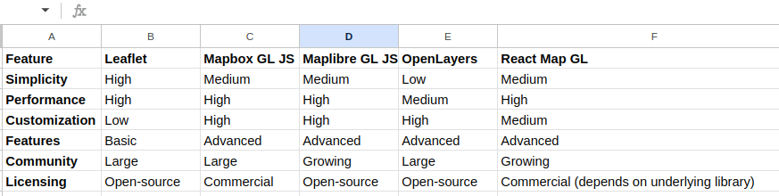
Remember that the best mapping library is the one that aligns perfectly with your project’s specific goals and constraints


Best Mapping Library: Perfect Tool for Geospatial Success