gis master

10 Signs You’ve Mastered GIS Software Skills

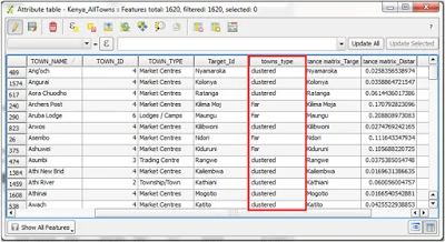
Mastery of GIS software skills empowers professionals to navigate through datasets, make informed decisions, and provide invaluable insights that drive positive change. In a nutshell, a GIS master is an all-around professional when it comes to the GIS industry
spatial data science tools

A Deep Dive into Spatial Data Science Tools

At its core, Spatial Data Science is the discipline that focuses on extracting meaningful insights and patterns from data that has a geographic or spatial component. It marries the principles of traditional data science with the unique challenges and opportunities presented by spatial information

Display GeoJSON Data on Leaflet Map Using Vue JS

This article will focus on integrating Vue JS with Leaflet and outlining step by step process of displaying...
Future of GIS Feature

The Future of GIS

A few years ago, a lot of industries didn’t apply GIS in their operations, let alone apply it...

Nearest neighbor analysis in QGIS

GIS is very useful in analyzing the spatial relationships between features. It is important at times to find...
Virtual Layers in QGIS

Virtual Layers in QGIS

In a GIS project, there are so many data formats one can use for their analysis. Depending on...
UAVs

UAVs in the GIS industry: Applications, Trends and Future Outlook

The use of Unmanned Aerial Vehicles (UAVs) in the Geospatial industry has increased dramatically in the last few...
Remote Sensing Technology

Remote Sensing Technology: Monitoring water hyacinth

Satellite imagery offers low-cost and effective monitoring of the temporal and spatial distribution of water hyacinth infestation at a large scale

Begin developing in GIS

For the last few weeks, I have been putting together some ideas that I gathered from different environments...

GIS impacts in the East African Region

In this blog, we shall explore the various GIS impacts within this region in the recent past and...

Latest Posts

See latest posts