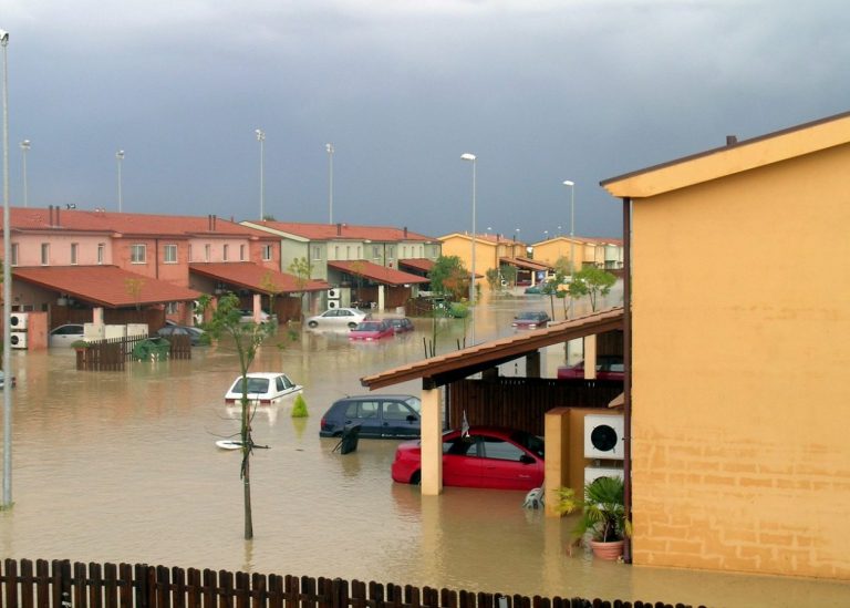
Menu
Life in GIS
Search

Life in GISLife in GIS

Menu
  • About
  • GIS
  • Remote Sensing
  • Geo-Stories
  • Downloads
  • GIS Terms & Definitions
  • QGIS Course
Search
close
Life in GISLife in GIS
close
  • About
  • GIS
  • Remote Sensing
  • Geo-Stories
  • Downloads
  • GIS Terms & Definitions
  • QGIS Course
Create a web map

Life in GIS is your go-to-site on GIS tutorials, Web-GIS Development, GIS Articles, Geo-Stories, Remote Sensing, UAVs, GIS Data, GIS Tutorials.The platform was established as an initiative to share knowledge within the GI sector in which tutorials, both text, and video, have been used for this purpose

Stay in the loop

Categories
  • Posted inin GIS
  • Remote Sensing

Landsat 8 in Land Surface Temperature Estimations

  • Posted byby Samuel Gachuhi
  • 0 Comments
  • 11 min
  • 11 min
    • Share
Speaking of high temperatures or land surface temperature estimations, our advanced spaceborne sensors have been collecting the earth’s...
  • Continue Reading
  • 11 min
gis news
Categories
  • Posted inin GIS News

Latest GIS News – What You Need To Know This Week

  • Posted byby
  • 0 Comments
  • 3 min
  • 3 min
    • Share
So much is happening within the GIS industry this week. In addition to last week’s GIS news, this...
  • Continue Reading
  • 3 min
GIS Approach
Categories
  • Posted inin GIS

A GIS and Remote Sensing Appproach: Food Security

  • Posted byby
  • 0 Comments
  • 3 min
  • 3 min
    • Share
A bare land lies at the foot of an unnamed hill—the locals are unconcerned with such trivial matters....
  • Continue Reading
  • 3 min
Categories
  • Posted inin GIS
  • GIS Programming

5 Python and R Libraries For GIS

  • Posted byby
  • 0 Comments
  • 3 min
  • 3 min
    • Share
This article looks at the best Python and R studios for GIS mapping.
  • Continue Reading
  • 3 min
gis news
Categories
  • Posted inin GIS News

Latest GIS News-What You Need To Know This Week

  • Posted byby
  • 0 Comments
  • 3 min
  • 3 min
    • Share
GIS in Telecom Market to Surpass $4,482.8 Million Value by 2030, finds P&S Intelligence According to the market...
  • Continue Reading
  • 3 min
Categories
  • Posted inin GIS

GIS Analyst To GIS Data Scientist – 8 Things You Should Know

  • Posted byby
  • 0 Comments
  • 3 min
  • 3 min
    • Share
Are you a GIS analyst wondering how to become a GIS data scientist, but you do not know where to start? Well, you are not alone, as the geospatial industry is going through a major disruption. Here is why.
  • Continue Reading
  • 3 min
urban Planning
Categories
  • Posted inin GIS

Urban Planning Information System

  • Posted byby
  • 0 Comments
  • 3 min
  • 3 min
    • Share
On a weekday at 7:30 am, the traffic snarl starts a few kilometres from the town. With that...
  • Continue Reading
  • 3 min
Forests Kenya
Categories
  • Posted inin GIS
  • Remote Sensing

GIS Applications: Forest Mapping in Kenya

  • Posted byby Samuel Gachuhi
  • 0 Comments
  • 5 min
  • 5 min
    • Share
This past June, and yes in this year, the National Forest Resources Assessment Report 2021 was released. This news...
  • Continue Reading
  • 5 min
GIS-for-gender-equality
Categories
  • Posted inin GIS

GIS for Gender Equality: An Outlook

  • Posted byby Brenda Chepngetich
  • 0 Comments
  • 2 min
  • 2 min
    • Share
Gender equality is attained when women and men have equal access to rights and opportunities. Gender equality is...
  • Continue Reading
  • 2 min
GIS-Industry
Categories
  • Posted inin GIS

GIS Industry: The Growth and Trends

  • Posted byby Christian Lance
  • 0 Comments
  • 4 min
  • 4 min
    • Share
Introduction The GIS industry keeps expanding and is fascinating right now. Maps speak more effectively than words, geospatial analytics assists...
  • Continue Reading
  • 4 min
Fire-hazard-detection
Categories
  • Posted inin Remote Sensing

Post-Fire Hazard Detection (ALOS-2 & Landsat-8)

  • Posted byby Aaden TJ
  • 0 Comments
  • 2 min
  • 2 min
    • Share
Introduction A study was carried out to investigate the use of Advanced Land Observing Satellite 2 (ALOS-2) equipped...
  • Continue Reading
  • 2 min
Ensemble Methods
Categories
  • Posted inin Remote Sensing

Ensemble Methods in Machine learning

  • Posted byby
  • 0 Comments
  • 2 min
  • 2 min
    • Share
Ensemble methods(multiple classifier systems) Ensemble refers to using many to form one, similar to how one would gather...
  • Continue Reading
  • 2 min

Posts pagination

  • Newer Posts
  • 1
  • …
  • 3
  • 4
  • 5
  • 6
  • 7
  • …
  • 12
  • Older Posts

New QGIS Course

Editors Picks

Chosen by the editor

    • GIS
    Why Building Geospatial Web Apps is a Game of Trade-offs
    • Posted Wanjohi Kibui
    • May 1, 2025
  1. Web GIS development
    • Geodatabase
    Ultimate Web GIS Development Roadmap
    • Posted Wanjohi Kibui
    • November 12, 2024
    • Web GIS
    Best Mapping Library: Perfect Tool for Geospatial Success
    • Posted Wanjohi Kibui
    • August 8, 2024
  2. geospatial software development analysis
    • GIS
    Geospatial Software Development Cheatsheet
    • Posted Wanjohi Kibui
    • June 11, 2024

Follow Us

Join us

  • twitter
  • facebook
  • youtube

Trending

Popular Posts

  • geospatial company
    • GIS
    Why Geospatial Companies are Key to the Future of Data Strategies
    • Posted Wanjohi Kibui
    • May 29, 2024
  • map-projections
    • GIS
    Why are Map Projections so Confusing?
    • Posted Wanjohi Kibui
    • April 17, 2024
  • GIS portfolio image
    • GIS
    Building a Strong GIS Portfolio
    • Posted Wanjohi Kibui
    • March 1, 2024

Editors Choice

Top Picks

    • GIS
    Why Building Geospatial Web Apps is a Game of Trade-offs
    • Posted Wanjohi Kibui
    • May 1, 2025
  • Web GIS development
    • Geodatabase
    Ultimate Web GIS Development Roadmap
    • Posted Wanjohi Kibui
    • November 12, 2024
    • Web GIS
    Best Mapping Library: Perfect Tool for Geospatial Success
    • Posted Wanjohi Kibui
    • August 8, 2024

Popular

Popular Posts

  • Open-Source Web Maps
    • Postedby Wanjohi Kibui
    • 1 min
  • Geodjango Tutorials
    Adding data to ExtJS grid from PostgreSQL
    • Postedby Wanjohi Kibui
    • 2 min
  • Publishing maps using QGIS Cloud
    • Postedby Wanjohi Kibui
    • 2 min
2024 © Life in GIS