The Fourth Industrial Revolution is starting to pick up the pace, affecting several industries. The humanitarian sector is one of them, as several innovations are being built around the distribution of aid and development. GIS technology is here to help.
These innovations include GIS technology, drones, data science, artificial intelligence, the internet of things, and cryptocurrency. Let us take a closer look at gis technology and its impact on the humanitarian sector.
What is GIS?
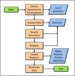
Let us first define GIS. ESRI defines GIS as a framework for gathering, managing, and analyzing data. Rooted in the science of geography, GIS integrates many types of data. GIS can be used to identify recurring problems, monitor and predict change, manage and respond to events, set priorities, and study and understand trends.
How is GIS Technology Impacting the Humanitarian Sector?
ASSISTING REFUGEES AND RESETTLEMENT
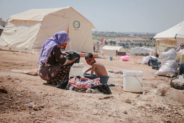
Many NGOs are using Geospatial technology to address the refugee issue. For example, humanitarian Organisation Medair uses the power of geo-ICT to help communities of refugees more efficiently. To reach Syrian refugees living in these scattered settlements, Medair’s Information Management team created a Geographic Information System. The system gives an address to Syrian families who lost their permanent homes in the conflict.
The mapped locations are updated in real-time and the information is made accessible to all humanitarian actors in Lebanon so that the needs of all refugees living ins informal settlements are recognized and addressed effectively. Even ten years after the initial influx of refugees, Medair maps more than 8,000 settlements every year.
LOGISTICS AND PLANNING
GIS can be a useful tool for logistics and planning, especially during a critical field operation. You can coordinate and monitor field operators, prioritize tasks, identify gaps, quantify the impact you are making, work agile and estimate how much ground you have to cover.
CONFLICT ANALYSIS
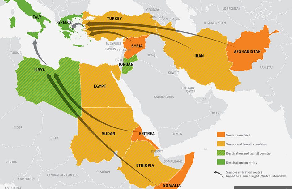
Conflict analysis is a vital part of delivering humanitarian assistance. One has to understand the dynamics of the conflicts, the actors involved, the flow of refugees, the areas affected and if the conflict may affect neighbouring countries.
GIS can help you do that; you can get a better sense of the violence by mapping out the actors, the territory that has been covered by the rebel and the flow of refugees.
IMPACT ASSESSMENT
According to IFDA, impact assessment is an approach to evaluate whether observed changes in outcomes among project target groups can be attributed to development projects.
Impact assessment is, in its simplest form, a planning method that is now generally regarded as an integral component of sound decision-making. It helps identify key issues and concerns of interested parties.
GIS is a great tool for impact assessment. It can help you gauge if you have impacted the people affected by the conflict, these could be in the areas of aid distribution or refugee resettlement.
ADVOCACY AND MEDIA ATTENTION
Media advocacy is the process of disseminating current-related information through the communications media, especially where the aim is to effect action, bring the public’s attention to a certain issue, or change policy.
Through proper GIS mapping, humanitarian organizations can engage in media advocacy to bring attention to the ongoing humanitarian situation at hand. Satellite imagery and GIS can play a big part in advocacy and media attention.
RISK ASSESSMENT
Risk assessment is a thorough look at the humanitarian situation to identify what may cause harm on the ground as you are distributing aid. After threat identification is made, you can analyze how likely and severe the risk is and how it can hamper your humanitarian relief efforts.
GIS can play a big impact in risk assessment as it can map out areas of high risk.
This can be very effective if an environmental disaster has occurred. One can map out the vulnerable areas and how the people living here can be helped.
MONITORING AND EVALUATION
The World Bank defines M&E as a continuing function that uses systematic collection of data on specified indicators to provide management and the main stakeholders of an ongoing development intervention with indications of the extent of progress and achievement of objectives and progress in the use of allocated funds.
Monitoring and evaluation are important processes after completing a humanitarian project. GIS Mapping can help you ensure M&E is done right. Center for Monitoring and Evaluation often recommended geospatial software as an essential tool for M and E.
Conclusion
Innovation and technology will play a crucial role in impacting the humanitarian sector. This sector should embrace it as it will go a long way in saving lives during a conflict or disaster scenario.
GIS is in the process of incorporating data science, the Internet of Things, machine learning, and artificial intelligence. This will also play a big part in how GIS affects the humanitarian sector as the fourth data revolution continues to take shape.


GIS Technology in the Humanitarian Sector