geodjango

Top Must-Have GeoDjango Packages

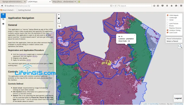
GeoDjango, a geographic web framework for Django, emerges as a powerful solution, seamlessly integrating spatial data types and geospatial functionalities. As developers navigate this landscape, exploring the top GeoDjango-related packages becomes paramount
ladm

A Land Administration Domain Model for Kenya

The Land Administration Domain Model (LADM) is the prevailing ISO standard on land administration and management. Through the use of this model, liaison with the NLC and other stakeholders
Remote sensing

Remote Sensing Applications: Built-up Assessment

It is a no-brainer why a majority of remote sensing applications are focused on land surfaces. Built-up area assessment is a key factor
GIS Companies

Top 10 GIS Companies

GIS companies offer a wide range of services including mapping, visualization, and analysis. We work with many datasets
Humanitarian Aid GIS

GIS Technology in the Humanitarian Sector

The Fourth Industrial Revolution is starting to pick up the pace, affecting several industries. The humanitarian sector is one of...

Adding layers from GeoServer in QGIS

In a GIS, the ability to handle more data formats is of key priority while developing the system....

Burn severity mapping using Imagery

Burn severity refers to the effects that fire intensity has on the functioning of an ecosystem in the...
GIS skill

Mastering Essential GIS Skills for a Successful Career

In today's dynamic job market, GIS skills are increasingly valuable, transcending traditional limitations and finding applications in diverse fields. It is essential to master essential skills, regardless of whether you are considering a career in GIS or already have one.
GIS programming

Should You Learn GIS Programming?

GIS programming is a crucial aspect of the GIS industry and offers many opportunities for professionals to enhance their skills.
GIS Applications

10 GIS Applications You Probably Didn’t Know

Geographic Information Systems (GIS) has many applications and benefits, but perhaps the most overlooked application among many GIS...

Latest Posts

See latest posts