ladm

A Land Administration Domain Model for Kenya

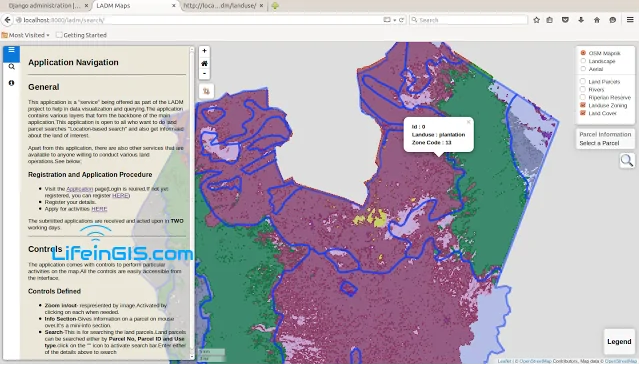
The Land Administration Domain Model (LADM) is the prevailing ISO standard on land administration and management. Through the use of this model, liaison with the NLC and other stakeholders

Burn severity mapping using Imagery

Burn severity refers to the effects that fire intensity has on the functioning of an ecosystem in the...
GIS Companies

Top 10 GIS Companies

GIS companies offer a wide range of services including mapping, visualization, and analysis. We work with many datasets

Importing vector and raster data in the GEE

Vector and raster data formats are used in the analysis in the Google Earth Engine. Vector data can...
GIS Approach

A GIS and Remote Sensing Appproach: Food Security

A bare land lies at the foot of an unnamed hill—the locals are unconcerned with such trivial matters....
GIS development platform

Choosing the Right GIS Development Platform for Your Needs

In the realm of Geographic Information Systems (GIS) development, selecting the appropriate platform is crucial for achieving optimal results. Whether you're building applications for mapping, spatial analysis, or data visualization, choosing the right GIS development platform can significantly impact the efficiency, scalability, and functionality of your solution. This article explores key factors to consider when evaluating GIS development platforms, helping you make an informed decision that aligns with your specific needs and objectives.
GIS skill

Mastering Essential GIS Skills for a Successful Career

In today's dynamic job market, GIS skills are increasingly valuable, transcending traditional limitations and finding applications in diverse fields. It is essential to master essential skills, regardless of whether you are considering a career in GIS or already have one.
gis development skills

Effective Tips to Enhance Your GIS Development Skills

Discover essential tips for building a strong foundation in GIS development skills. Become a proficient GIS professional today.
Geoserver

Display WMS from GeoServer on Leaflet using Vue.js

The Web Map Service (WMS) is an Open Geospatial Consortium (OGC) specification that defines an HTTP interface used...
Web GIS development

Ultimate Web GIS Development Roadmap

Introduction From online maps to real-time geospatial analytics, Web GIS has become an essential tool across industries like...

Latest Posts

See latest posts