Community security, world security, and disaster hazards are all developing and becoming more diversified and complicated. Climate change, population expansion, growing urbanization, environmental degradation, outdated infrastructure, social disintegration, and inequality all contribute to this trend. Availability of Geospatial Intelligence (GI), has proven to play a major role in the disaster management sector.
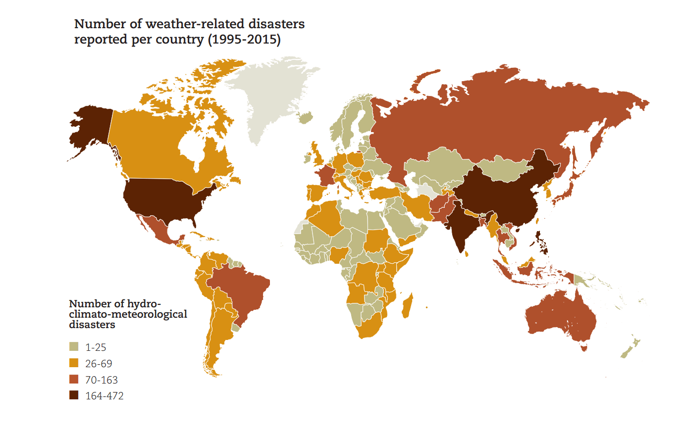
The scope, severity, and regularity with which these things happen is the most concerning aspect of the continuously growing hazards and risks environment. For instance, the public security community in the United States answers to about 300,000,000 emergency 911 calls every year and is expanding. Furthermore, these figures do not account for the increased demands for the reaction that arises amid natural catastrophes or large-scale crises.
Over the previous three years, approximately three out of every four Americans have been actively or passively harmed by catastrophes (violent extremism, floods, and hurricanes) through a direct family member or acquaintance. These catastrophes cost the American taxpayer $457 billion and resulted in the deaths of 3,663 people.
Destruction of infrastructure, public buildings, and natural ecosystems accounted for the great bulk of these expenses. These figures are frightening on their own, but when combined with others, they become much more so. They demonstrate that disaster dangers in the United States are not just a worry for property and lives, but also for our way of life since they undermine the country’s fiscal soundness and fabric.
These trends are wreaking havoc on America’s financial, physical, and psychological well-being, threatening our national, global, and economic stability in unimaginable ways. Without technical development and creativity, how can we change these patterns? How are major industries such as insurance and risk management reacting to the fast-changing dangers and threats landscape, as well as technology advancements? What are GEOINT’s present and future significance in catastrophe insurance and risk mitigation?
Understanding disaster risk
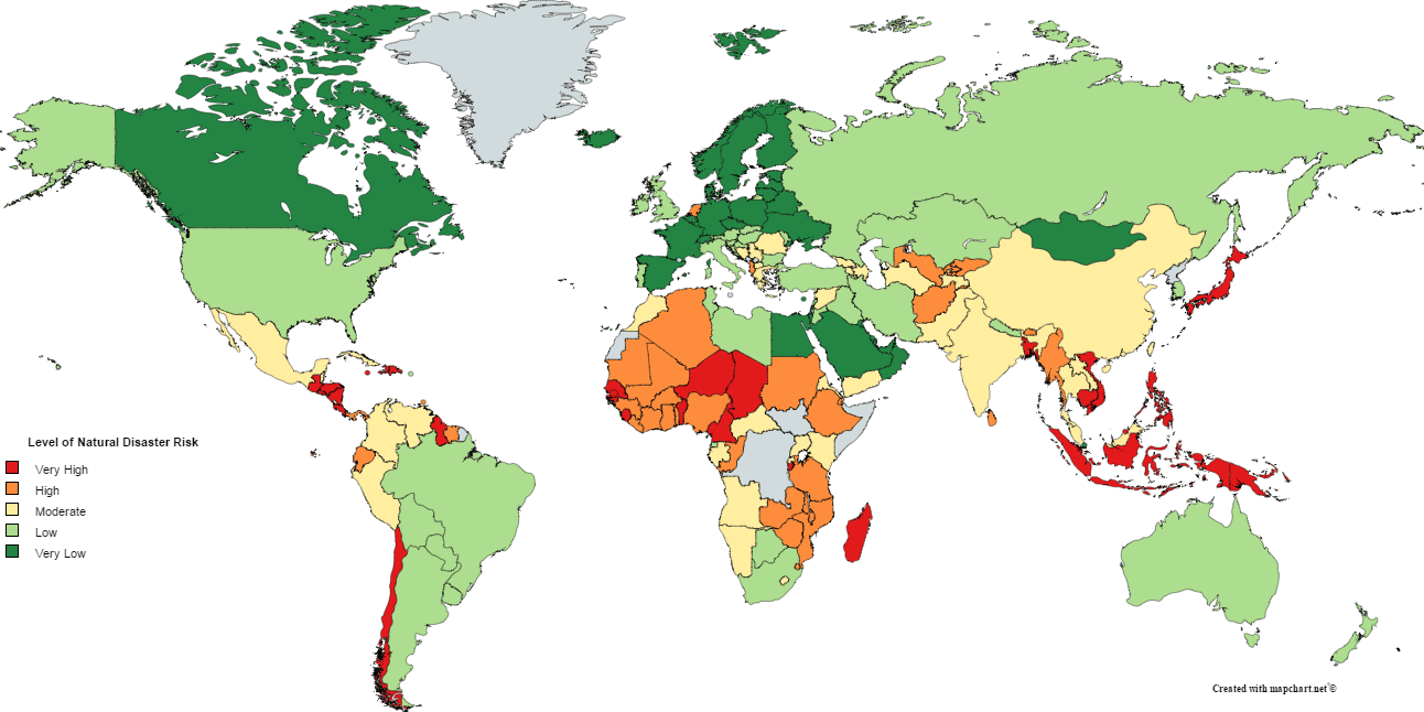
Assessing catastrophe risk is critical to rendering our cities more secure. Malaysia, for instance, anticipates an urbanization increase of approximately 85 percent by 2040, with a population of over 46 million. Considering the pressures of urban expansion, harsh weather, and environmental degradation, the incidence of disasters is growing, with a huge number of deaths, injuries, and infrastructure damage. As a result, there is an urgent need to evaluate the related risk drivers and primary causes, examine catastrophe preparedness, and construct resilient urban communities in disaster-prone areas.
Modern and sophisticated geospatial solutions offer enormous potential to aid in the provision of precise and up-to-date topographic information, dynamic land-use-land-cover alterations, human operations, and elements-at-risk, resulting in improved susceptibility, inventory, and risk map development. It increases comprehension of triggering variables and fundamental causes, allowing for a more accurate assessment of susceptibility and related risk.
The expansion of satellite information (earth surveillance, positioning, and connectivity) in conjunction with GIS-oriented modeling and Big Data analytics-based advanced methods rely on the machine and deep-learning methods enabled analysis, real-time analysis, and evaluation.
Remote Sensing
Sensor-dependent permanent surveillance is now possible because of High Altitude Pseudo Satellites and a plethora of micro-sats. In the early aftermath, hand-held drones can give local contextual information. China is constructing a nationwide network of unmanned aerial vehicles (UAVs) to reach any catastrophe site within four hours. The United Kingdom Space Agency is collaborating with Pacific island governments to integrate meteorological and geospatial intelligence for accurate climate-resilience choices.
The 1908 Messina tsunami and earthquake killed 100,000 people in Calabria and Sicily, making it one of Europe’s greatest recent natural catastrophes. Understanding tsunami catastrophe risks, on the other hand, will be made a bit simpler by remote sensing. With its 500kg LIDAR sensor, NASA’s IceSat 2 can identify the form of the bottom as deep as 40 meters, enabling improved tsunami effect modeling.
Land elevation information is particularly critical for assessing the hazards of landslides and liquefaction, both of which were the main causes of death during the 2018 Sulawesi tragedy. Remote sensing information, on the other hand, has limited utility on its own. Associated advancements in quick environmental evaluation applications based on pattern recognition and extraction of features, as well as later greater data integration, are creating opportunities to obtain actual value from remotely sensed data, regardless of its source.
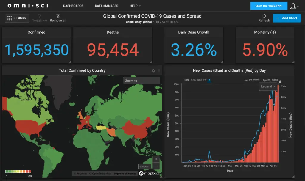
Responding to COVID19 pandemic
To monitor the transmission of an infection, determine risks, control infrastructure, and focus countermeasures, reliable epidemiological surveillance relies on common geographic data. Geospatial data is not only important for the business sector, security, and safety, but it also serves as the basis for several e-government programs like utility management, asset registration, and the development of smart cities.
Geospatial solutions are transforming the economy in the internet world. Digital services based on GPS and present mapping information, such as socioeconomic data and housing prices, have silently become daily occurrences and trade, from navigating public transportation to monitoring supply chains and arranging effective transport routes.
Semi-automated geospatial technologies founded on urban sensing, earth surveillance, and mobile contact-tracing, combined with machine learning, artificial intelligence, and computer vision, for example, are rapidly expanding and significantly controlling the COVID-19 assessment. Technologies like big data analytics, automated mapping, and monitoring of land-use changes cut expenses and increase real-time resource management.
Three-dimensional and “Digital Twin” techniques are proliferating and supplanting 2D maps, blueprints, and procedures. With the advancement of mobile tech and connectivity, portable cellphones have liberalized mapping, putting geospatial intelligence in the hands of everyone. Bottom-up, consumer-driven, and commercial information software and applications are novel and have had significant societal implications.
Terrorism
The use of GIS in counter-terrorism begins with surveillance and monitoring in order to forecast the four aspects (when, how, where, and who) of terrorist activities. It then carries on to communicate crucial information through other government agencies, intelligence organizations, and homeland security devices. Terrorist attacks generally have a planning cycle. It does not occur by chance. As pre-attack events take place over time, any terrorist activity exhibits distinct temporal patterns. Simultaneously, the planning reveals a bimodal spatial trend of preparation and choosing a target.
The geospatial tool can map out the terrorists’ pre-attack operations in space and time. For a choice support framework, this data is immediately accessible. The following are the stages of GIS implementation:
- Terrorist operations, artificial terrain, cross-border money laundering, and maritime operations all have a spatial dimension to them. Patterns and hot areas are superimposed on maps to analyze terrorist activity trends in real-time.
- Risk evaluation is carried out depending on the aforementioned. Personalities, targets, and locations that are vulnerable are selected. Terrorists/terror organizations that have made abrupt migrations or expanded their activity are studied and geographically connected with ethnic, political, and other aspects.
- Response: GIS allows agencies to share data and assessments in order to develop a tactical approach. Potential assaults can be avoided by employing geospatial techniques and technology, which have proven indispensable in military and police intelligence.
- Mitigation: Forecasts of probable terror attacks aid in the development of tolerance against loss of property and life. Existing satellite images and base maps are layered in instantaneously with crowdsourced data, terrorist locations, drone monitoring data, and geo-tagged social media activity.
Once again, Geospatial intelligence plays a critical role in anti-terrorist efforts. Maps are the most important tool for tracking terrorist activities, coordinating with ground forces, and preparing for real police pursuits or conflict. To comprehend terrain and strategy with absolute accuracy, satellite photos and LiDAR data are employed. UAVs are utilized to locate positions, photograph them, and transport supplies to inaccessible locations.
Conclusion
Where will the next calamity strike? Are we prepared? We are seeing an increase in the financial and human costs of catastrophes as a result of climate change, at a time when geospatial abilities are increasingly beneficial to Disaster Risk Management(DRM).
DRM is becoming the driving force for incomplete national geographic data networks in various countries; no minister desires their ministry to be blamed for being unprepared. Resilience Direct, a tool developed by the UK’s Civil Contingency Secretariat and formerly highlighted on DGI, is the UK’s geographic ‘single operational picture‘ tool. Disaster planning and response is an excellent example of how geospatial intelligence can benefit authorities at all levels. Every chance to encourage this must be used, making use of our current international and cross-government ties.


Geospatial Intelligence in Disaster Risk Management