
A Shapefile is an essential component for anyone who works with geographic data. This article will explain what they are, why they’re important, and how to create them. Shapefiles are a standard way to store and share spatial data. Shapefiles are used in GIS software programs, web mapping services, and many other applications depending on project requirements.
What is a Shapefile?
A shapefile is a collection of geospatial features stored as a series of coordinates. It’s a database of points, lines, polygons, and multi-polygons.
Shapefiles are used by GIS professionals to store information about geographic features such as roads, rivers, buildings, etc. A shapefile is an ASCII text file that contains information about geographic features in a specific area. A shapefile can be termed as a collection of points (also called vertices) that define a point on the ground. These points are then connected together to form a line. This process creates a shapefile.
What makes a shapefile?
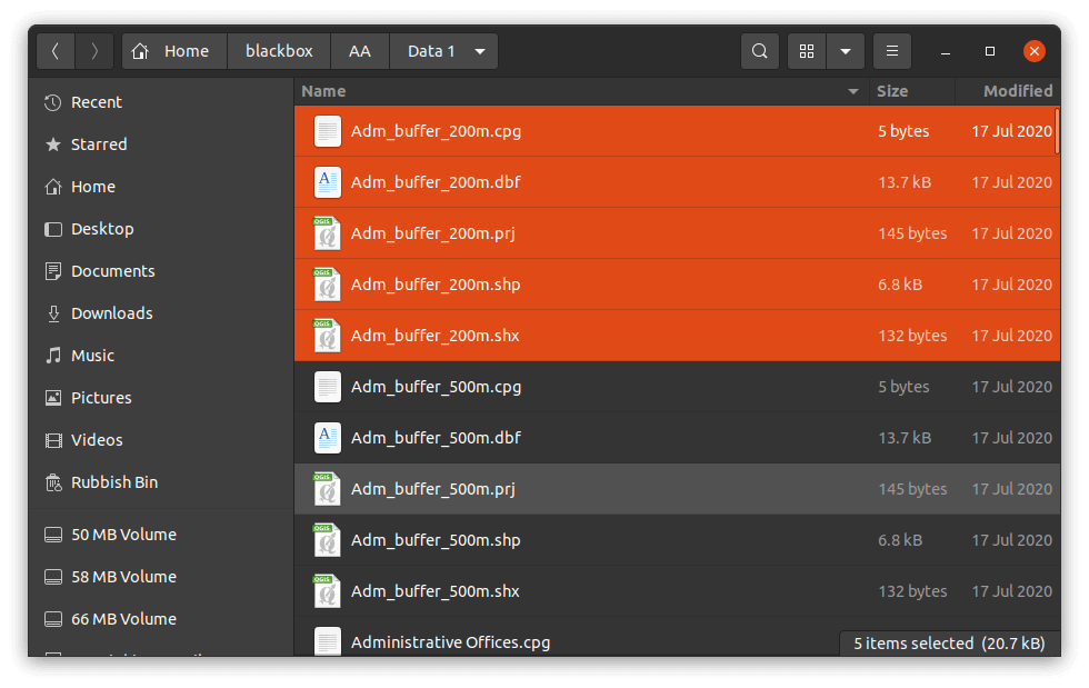
Usually, a shapefile contains a number of files(types of shapefiles). There are mandatory files and optional files. As shown in the image below, there are file extensions such as .shp, .shx, .prj, .dbf and .cpg
Among the files highlighted, the mandatory files include;
- .dbf – This is the database file. This file is responsible for storing data used in for example the attribute table
- .shp – This file contains the geometry visualized on the various GIS software used.
- .shx – This is the index and offsets information file. It helps to access information about features in the shapefile.
Other files contained in the shapefile definition are optional with some files representing project files based on the software used to generate them.
Why Do You Use Shapefiles?
If you work with GIS software, you will need to use them. There are two main reasons why you would use them: 1) to share data between different programs; 2) to make sure that the data is accurate. They allow users to store and share spatial data. This includes storing maps, topographical data, and other geographical objects
How Can I Create a Shapefile?
You can create your own shapefile using any program that allows you to save files as .shp. This includes ArcGIS, QGIS, Google Earth, and others. To do so, you will require different steps based on the GIS software in use. In general, one can follow these steps: 1) Open up the file format you wish to use; 2) Save the file as a.shp file; 3) Name the file whatever you want; 4) Click “Save As”; 5) Choose where you want to save the file; 6) Click “OK”.
This process of digitization of raster files produces vector layers. There are many ways, based on the environment, of producing shapefiles for your projects. You can find some use cases that are practical depending on the project.
There are many benefits to using shapefiles. One advantage is that they are easy to share with other people. Another benefit is that they are easily editable. If you need to make changes to a shapefile, you can simply open it up again and make the edits.


Nice article but I think we should all be aware also of what are the consequences in using shapefiles. There’s a site (in which I’m not involved at all) explaining the main concerns: http://switchfromshapefile.org