It’s quite some time since I talked about Web-GIS development on this blog. In the last year, I have had a great time exploring different mapping platforms and testing any platform that I came across. Web-GIS is a field in which over the last few years, has really seen the light of the day as every organization struggles to migrate to the cloud.
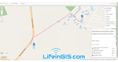
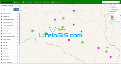
As I have been interacting with the industry and organizations in different areas, web-GIS is an area every manager is interested in. Cutting-edge solutions to handle organizational activities and operations are being developed day in day out. To illustrate a web GIS, I will take a look at a project developed for the Agriculture sector “ AgriDSS” which serves as a decision support system for both the management and the citizens. The system had a number of functionality;
- A routing system
- Incidence Reporter
- A map dashboard
- Front-end and back-end
- User registration process
- A news broadcaster
- Crop information communicator
- Query tool
- An event planner
- Map printing capabilities
- Data download tool
- e.t.c
In this system, user data management and interaction was of key focus and the developed sections seek to solved this utmost need.
Such systems, they are very useful to both the administration and also to the citizens.As the number of internet users in Kenya continues to skyrocket, these systems will be of great need and help to all.
A lot is done in the agriculture sector that need modern day solutions to increase service delivery and maximization of yields in our farms.
The following are some of the screen-shots of the developed Decision support system.

Whats your take on this? leave a comment below.


This comment has been removed by the author.
The world ???? is getting "cloudy" ☁ so is GIS. Virtualization of GIS systems and services is fast gaining momentum. For scalability, quality service delivery,profitability, and relevance in the market, GIS firms ought to embrace cloud computing and Virtualization.
The world ???? is getting "cloudy" ☁ so is GIS. Virtualization of GIS systems and services is fast gaining momentum. For scalability, quality service delivery,profitability, and relevance in the market, GIS firms ought to embrace cloud computing and Virtualization.
Very true Vincent. GIS on the cloud has become inevitable. We ought to upscale our industries to reach this mark for the purposes of better businesses
Am in Agriculture sector. Remote Sensing and GIS is the way to go.
I don’t know how can I give you thanks! I am totally stunned by your article. You saved my time. Thanks a million for sharing this article.
Welcome.Thanks too for the feedback
Boss ,
Am interested in mastering programming , cartography, spatial Databases
Am doing GIS in Malawi
Please advice me