The global GIS industry is estimated to be worth $21.71 billion in 2030, growing at a CAGR of 12.1% from 2022 to 2030. This growth is being driven by the increasing demand for GIS solutions in a variety of industries. As a result, the demand for GIS professionals has gone up, more so for GIS developers. A career in GIS development involves various responsibilities and can be either challenging or smooth, depending on the individual’s experience. Along the way, you encounter several GIS development challenges, but there are also rewarding highs.
The GIS development career demands diverse skills like programming, cartography, and spatial navigation, combining art and science. GIS developers play a crucial role in transforming data into visually engaging maps, presenting complex information in a clear and accessible manner. They meticulously choose colors, symbology, and map layouts, ensuring accuracy and aesthetic appeal. This cartographic creativity enhances the impact of GIS applications, making them more engaging and user-friendly.
In my years of experience, I’ve learnt a lot in terms of technical and non-technical skills. There are better days and gloomy days. Regardless of the days, the journey has been an interesting one. I will tell you the highs I have experienced before I dwell on the challenges in the GIS development world and the possible solutions.
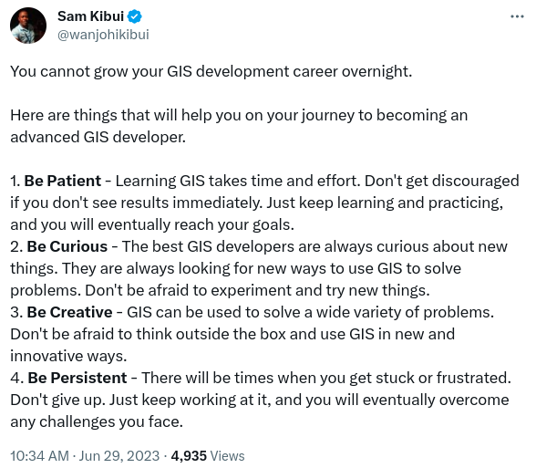
The Highs of the GIS Development Career
- Innovative Problem Solving – They’re days you just sit and think, “What the hell is this issue?” “How do I deal with this?”. All are these require you to think widely in order to find a solution. Remember, the client awaits the solution. In such cases, you have to think “outside the box” to find a solution. In so doing, you learn new ways of doing things.
- Positive Impact – It feels good to know or see clients using your systems or outputs. Your clients use the solutions to make crucial decisions in the real world and deliver services to their clients/audiences. These solutions have a chance to bring positive change to communities, governments and institutions.
- Multidisciplinary Learning – There are days you will go without touching anything “geospatial” in your daily tasks. Why? you’re busy learning or using stuff from other disciplines to provide solutions. In the long run, you end up knowing so much about other fields. This knowledge too, right?
- Continuous Improvement – As you all know, the GIS field is ever-evolving. There are many learning opportunities for all in this career. With new technologies, software updates, and best practices, the quest for knowledge is a pursuit that ensures constant growth.
- Time Management – In this industry, tasks and projects are time-bound. You have to be a good time manager to ensure the timely delivery of projects or solutions to your clients. This is key.
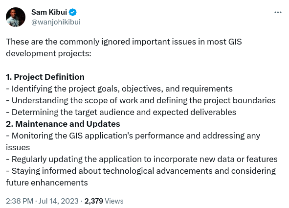
Challenges in GIS Development Career
Let’s get to the challenges that often emerge as roadblocks on this journey and, in turn, the strategies to overcome them.
- Confusing Learning Path
This is the first on the list since everyone has experienced this. You’re not alone. The GIS field is wide; many tools, libraries, frameworks, data formats etc. It is difficult for newcomers to navigate and decide where to start their learning journey.
Possible Solution: Begin with the fundamentals of GIS, including spatial data concepts, coordinate systems and basic GIS software. Focus on one GIS software or platform initially (e.g. ArcGIS, QGIS) to avoid overwhelming yourself. Follow structured online courses or tutorials that offer step-by-step guidance. As you gain confidence, explore more advanced topics and expand your skill set. You can check out how I learnt GIS development.
- Lack of Practical Experience
This has been a challenge to many upcoming developers at one point or another. There are times you think you know enough or so much only to be shocked at some point. As I usually say “Don’t call yourself an expert, let the industry do“, there is so much to know and do. In a nutshell, practical experience is key in this very technical field.
Possible Solution: Engage in personal GIS projects, such as creating interactive maps, analyzing spatial data, or solving real-world problems using GIS tools. Also, you can look for internships or entry-level positions that provide hands-on experience. In addition to internships, participate in GIS-related competitions or hackathons to showcase your skills and build your portfolio.
- Keeping Up with Evolving Technology
Every now and then, there is a new framework, library or platform. Some are worth keeping up with while others might not be. As new versions of existing tech come out, there are often issues to do with code breakage if not system failures. You have to keep up with the trend to be relevant tomorrow. It’s your job to ensure this.
Possible Solution: Set aside time for continuous learning and professional development. Also, follow GIS-related blogs, forums, and industry publications to stay informed about new trends and tools. You can also attend webinars, conferences, and workshops to learn from experts and network with other GIS professionals.
- Knowledge Gaps and Skill Development
As mentioned in the highs section above, GIS development requires a multidisciplinary skill set. This might involve programming, data analysis, and cartography just to mention a few. Ideally, filling knowledge gaps in all these areas can be challenging.
Possible Solution: To solve this, break down your learning into manageable chunks and set achievable learning goals. Seek resources like online courses, workshops, and textbooks to enhance your skills in specific domains.
- Limited Access to GIS Software and Data
In today’s GIS landscape, Open-Source GIS software has become popular, leading to more users of GIS participating in tasks and activities. However, if the requirement for the job is proprietary software and high-resolution geospatial data, it can be costly or restricted to many, more so individuals or small organizations.
Possible Solution: Explore open-source GIS software, which offers powerful capabilities without a cost. Also, you can utilize open data portals and crowd-sourced data initiatives for free geospatial data. In addition, Consider cloud-based GIS solutions that offer pay-as-you-go options, making it more affordable for small-scale projects.
- Poor Data Quality
As highlighted in the point above, obtaining and maintaining high-quality spatial data is a significant challenge. Acquiring data from different sources may have errors, inconsistencies or incomplete leading to unreliable outputs after analysis.
Possible Solution: Invest in data validation and cleaning processes. Also, work with metadata to understand data sources and limitations. You can also collaborate with data providers to ensure data accuracy.
- Interoperability and Data Formats
A typical GIS application handles data from various sources and formats. In some cases, you will experience incompatibility of these datasets with your application. This means that you have to do a lot of data conversion to the required formats. In return, the conversions can alter the data or hinder data integration.
Possible Solution: Use standard data formats like GeoJSON or shapefiles if possible. Also, for analysis, you can go for software that supports multiple spatial data formats.
- User Interface and User Experience (UI/UX)
Every one of us has used an app with cool user interfaces and another app with boring interfaces. Depending on the skill set, creating intuitive and user-friendly mapping interfaces can be demanding. More so, when dealing with complex or hierarchical datasets, the user experience can be challenging.
Possible Solutions: First, engage with end users to understand their needs and pain points. Secondly, follow UI/UX design principles and conduct usability testing to refine the interface. Lastly, engage a professional UI/UX designer.

- Performance and Scalability
This is very common when dealing with large GIS datasets. Processing and rendering large spatial datasets is resource-intensive and slow leading to poor user experience. Since most developers do not own powerful personal computers or supercomputers, it can be a pain point.
Possible Solution: Optimize data queries and data indexing. Another option would be to use clusters to bundle large datasets for rendering. Also, if you have complex processing, you can utilize powerful data processing engines such as Google Earth Engine (GEE) or even Mapbox. In addition, you can also publish large datasets and consume services such as WMS, WFS (GeoServer)
- Integration with Other Systems
I have encountered this challenge every now and then. Imagine integrating a system that does not support any kind of external communication. What do you do? Integrating GIS with existing systems, such as enterprise databases or web applications, can be complex due to differing architectures and data structures.
Possible Solution: First, before starting a project, know the scope. Evaluate the systems to be integrated and highlight that with the client before starting the work. This eliminates chaos during project implementation. Also, If a situation presents itself, use standardized APIs and protocols for integration. In addition, you can develop middleware or APIs to bridge the gap between systems.
- Resistance to GIS Adoption
This also forms the list of GIS development challenges. This is a common phenomenon which I have encountered many times. You start a project and execute it as required but when you get to implementation, you get a cold response from stakeholders. Some stakeholders may be resistant to adopting GIS solutions, either due to a lack of awareness or scepticism about its benefits. Others resist the solution for selfish gains or personal reasons.
Possible Solution: There are a couple of things to do here. First, you can educate stakeholders about the value of GIS through case studies and demonstrations. Secondly, involve all relevant stakeholders at all stages of the solution development. Thirdly, you can start small, with a pilot, to showcase success. Lastly, handle the situation professionally through the right communication channels and agree as a unit.
- Poor Documentation
One of the crucial decisions a GIS developer has to make in every project is the choice of libraries, tools and extensions to use. In most cases, one will choose these platforms based on experience. Some of these libraries are well documented compared to others. This might seem easy but can be tough as the project goes by.
Possible Solution: Be very keen when choosing these libraries to avoid getting stuck later in the project. Also, go for a library with a good community backing it. At least you can ask for help when stuck.
- Poor Reporting & Documentation
A typical GIS solution project will have an end-user training or manual preparation phase. Developers fail at providing clear guidelines to operate the system. This in return leads to resistance from end users. Also, for purposes of the future, it’s good to document your work.
Possible Solution: Include inline comments in the code. Also, include ReadMe files in your project. To make things easier, you can use code documentation tools such as Javadoc (for Java), JSDoc (for JavaScript) or even Sphinx (for Python) to generate documentation. You can also use Version Control systems such as Git to maintain a clear history of changes, bug fixes and enhancements in each version of the system.
- Project Management
In many GIS projects, you will have to work with teams or systems. The quality of management put in determines the success of the project. The management can be in terms of teams, resources and other components. Having a weak project lead can also mess up the project. The project management team must possess the right skills to steer the project forward and achieve the tasks put in place. Also, a delay in one output can delay the other components of the project.
Possible Solution: Understand your roles completely before starting a project. Engage professionally with other team members and communicate accordingly.
- Lack of Consistency
This is a crucial point to consider. It cuts across different perspectives. One is the self-development part and the other is in regard to project implementation. On self-development, maintaining a consistent routine for learning GIS development can help you learn faster and keep up with the changing industry paradigms. Also, as often known, some skills such as programming, once abandoned for a few months, can be tough when you return. You need to keep on it.
On project implementation bit, lack of consistency can mean the absence of standardized practices, formats, and methodologies within a project or across different projects. Inconsistent approaches can lead to confusion, errors, and inefficiencies, hindering the overall development process. This can be due to changing team members, inadequate training, diverse skill sets or absence of standards.
Possible Solution: One of the solutions is to establish clear guidelines. Other solutions would be to allow code reviews, training teams, regular team meetings and continuous improvements for individuals.
GIS development challenges can be many. The list above is from experience and represents the majority of developers out here.
If you have experienced other challenges apart from the ones listed, let us know in the comments section.
Also, follow me on Twitter and access my daily nuggets of GIS development.


GIS Development Challenges and Solutions